Zumaia
Camino del Norte
Zumaia sits at the confluence of two rivers and is best known for what lies just offshore: the Flysch formations, layers of sedimentary rock tilted nearly vertical by tectonic forces and exposed by erosion into dramatic alternating bands of hard and soft stone. These cliffs record over 60 million years of geological history, including the K-Pg boundary layer — the thin band of iridium-rich clay that marks the asteroid impact that ended the dinosaurs. The Basque Coast Geopark, a UNESCO Global Geopark, is centered here, and the Algorri Interpretation Centre explains the science.
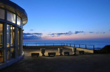
In town, the Iglesia de San Pedro Apostol is austere but contains oil paintings of 15th-century merchant ships and several side chapels. On the north end, near the coast, the Ermita de San Telmo occupies a dramatic cliff-edge position above a small cove. The ermita gained modern fame as the wedding location in Ocho Apellidos Vascos — the highest-grossing Spanish film ever — and tour buses arrive regularly.
Good services — bars, restaurants, shops, accommodation. The alternative Ruta del Flysch follows the GR-121 along the coast from here, passing San Telmo and the rock formations before rejoining the main camino near Deba.
San Pedro on the 29th of June.
The flysch formations along the coast between Zumaia and Deba were studied from the 19th century, but their global significance wasn't fully recognized until the discovery of the K-Pg boundary layer here — physical evidence of the mass extinction event 66 million years ago. The Basque Coast Geopark was admitted to the European Geoparks Network in 2010 and subsequently designated a UNESCO Global Geopark.
Just over this second footbridge, the camino splits. The official camino continues straight ahead and upwards through town. The alternate route again follows the GR-121 by turning right. They rejoin within 3.5km. The alternate route, known as the Ruta de Flysch because it crosses the sedimentary rock formations characteristic of this coast, is way marked and passes the Ermita de San Telmo. Both routes pass a public restroom shortly before arriving in Elorriaga.
Comments