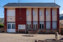
Poladura de la Tercia
Camino de San Salvador
Poladura is a small mountain town and the launching point for the most demanding section of the Camino del Salvador. The albergue is located in the former schoolhouse, and the only place to eat is the Posada El Embrujo — a good meal in a warm setting. Call the day before to give them notice: +34 659 030 282.
Take this stop seriously. From here to the Puerto de Pajares, the camino climbs over 350 m through 8 km of exposed mountain terrain. There is no cell coverage along much of the path, and snow can obscure both the trail and its markers well into the summer months. Charge your phone, fill your water, eat a proper meal, and study the route description before setting out.
The section between Poladura and Puerto de Pajares is the most challenging on the entire Camino del Salvador. The 8 km climb gains over 350 m through mountainous terrain with no services, no shelter, and limited cell coverage. Snow can cover the path and its markers well into summer. If visibility is poor, conditions are icy, or you're not confident in mountain navigation, consider taking the road via Arbas instead. Your life is worth more than any stretch of Camino.
The only meal in town is at the Posada El Embrujo. Call the day before to give them notice: +34 659 030 282.
The Tercia valley takes its name from the medieval "tertia" — the third part of the territory administered under Leonese feudal divisions. These mountain settlements were historically dependent on pastoralism and the transit trade crossing the Puerto de Pajares between León and Asturias. The difficult terrain kept these communities small and isolated well into the modern era.
Leave Poladura along the road. At the first bend to the left, the camino leaves the road to cross a small field. A brown mojón is visible from the road and marks the start of the mountain route. The first 1.3 km go uphill due northwest to an opening between two rocky outcroppings.
Another 300 m of visible paths and the trail turns left, continuing around the hill in a clockwise direction — downhill on your left, uphill on your right. It reaches a low point and begins climbing the next hill to the west. The trail turns south at around 2.3 km and shortly after takes a right turn, followed by another right 300 m on.
Another 500 m on the well-worn path comes to an end, but the camino continues straight, climbing steeply. You'll reach the high point at approximately 1,580 m altitude, about 4 km from Poladura. Markers for the next section are often obscured by ground cover or snow — be extra attentive.
Descend from here due north-northwest for 300 m. The path turns right and then splits. Do not continue straight and downhill. Turn left and begin another climb to a ridge. Follow the natural curve of the ridge for 600 m and turn left toward the ridge to your west. It's that ridge you'll follow into Arbas.
Accommodation in Poladura de la Tercia.
| Albergue Antiguas Escuelas Poladura de la Tercia 9€ 12 |
|
| La Posada del Embrujo ⭑⭑⭑ | 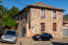
|
Comments